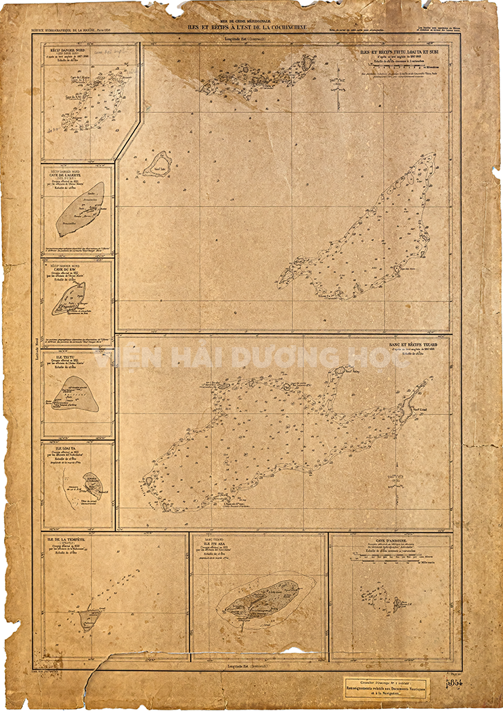
Đảo và các rạn san hô ở phía Đông của An Nam – Các đảo và rạn san hô Thị Tứ, Loại Ta và Su Bi
Năm xuất bản năm 1938
Kích thước bản đồ: 53 x 75 (cm)
Bản đồ do Sở thủy đạc Hải quân Pháp xuất bản năm 1938 tại Paris. Bản đồ được vẽ dựa trên số liệu do người Anh vẽ năm 1867-1868, và các chuyến khảo sát của 3 tàu Pháp là La Malicieuse, L’Aviso Alerte và L’Astrobale từ năm 1930-1933.
Bản đồ mô tả các đảo ở Quần đảo Trường Sa (cụm Thị Tứ, cụm Loại Ta, đá Su Bi, đảo Ba Bình/Itu Aba, bãi san hô Tizard, Cụm An Bang/ Amboyna Cay, cụm Song Tử/ North Danger Reef, đảo Trường Sa/Tempête) là một tập hợp gồm nhiều đảo san hô, cồn cát, rạn đá (ám tiêu) san hô nói chung (trong đó có rất nhiều rạn san hô vòng, tức rạn vòng hay rạn đá san hô vòng, “đảo” san hô vòng) và bãi ngầm rải rác từ 6°12′ đến 12°00′ vĩ Bắc và từ 111°30′ đến 117°20′ kinh Đông ở giữa Biển Đông. Bản đồ mô tả hình thái các đảo và độ sâu xung quanh đảo và trong các rạn san hô vòng.
Mer de Chine Méridionale: Iles et Récifs à l’est de la Cochinchine – Iles et Récifs Thi Tu, Loai Ta et Subi
Publish year: 1938;
D’après un levé Anglais de 1667-1868; Service hydrographique de la marine 1938.
The map was published by the French Naval Hydrographic Service in Paris in 1938. The map was drawn based on data collected by the British in 1867-1868, and the surveys of three French ships: La Malicieuse, L’Aviso Alerte, and L’Astrobale from 1930-1933.
The map describes the islands in the Trường Sa archipelago (the Thị Tứ cluster, the Loại Ta cluster, Su Bi rock, Itu Aba Island, Tizard Reef, the An Bang cluster, the Song Tử cluster, Tempête Island) as a collection of many coral islands, sandbars, reefs (shoals) in general (including many circular reefs, that is, reef rings or circular reef rocks, “circular reef islands”) and scattered shoals from 6°12′ to 12°00′ north latitude and from 111°30′ to 117°20′ east longitude in the middle of the South China Sea. The map describes the morphology of the islands and the depths around the islands and in the circular reefs.
The map is significant because it is one of the earliest maps to accurately depict the Trường Sa archipelago. It is based on data collected by the French, who were the first European power to conduct a systematic survey of the archipelago. The map shows the location of the major islands and reefs in the archipelago, as well as their depths. It is an important historical document that provides evidence of Vietnam’s long-standing claims to the Trường Sa archipelago.